The Lines That Would Not Move
The animal was walking through a highway interchange.
That was the first wrong thing.
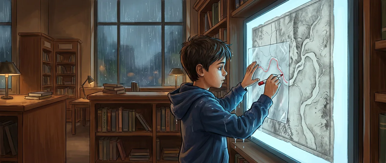
Soren stood in the public library with rain dripping from his sleeves onto the carpet and stared at the wall screen beside the nonfiction shelves. The screen was supposed to show a news article about migration. Instead it showed a map of eastern Africa, a braided knot of colored lines, and one red warning box.
Corridor flagged. Repeated individual movement across paved road, rail line, and irrigation canal. Not previously documented by field teams. Cause unknown.
Soren read it twice.
The colored animal was called EAF-two-nine-one, which was not a name, exactly, but it was the closest the computer had. The article said researchers had fed years of very sharp satellite images into an artificial intelligence system. On cloudless days, the system could pick out very large animals from above and match repeated sightings over time. Not every day. Not every animal. Just enough flashes, across years, to draw paths no one on the ground had followed.
This one went through a highway interchange.
Soren tapped the screen with one wet finger.
“Don’t smudge the display,” said Ms. Renner from behind the circulation desk.
“I think the map is broken,” Soren said.
“So is the receipt printer,” Ms. Renner said. She had the printer open with a pencil stuck behind one ear and a strip of paper curled around her wrist. “Everything is broken at four forty-five.”
Soren wiped the screen with his sleeve, which probably made it worse.
The line did not go away.
He zoomed in. The highway widened into pale loops. A railroad cut across it like a ruler mark. Square fields spread around both, bright and rigid. The red animal path approached from the south, narrowed, crossed the hard tangle, then opened again on the other side.
“No,” Soren said.
Ms. Renner looked up. “No what?”
“No animal would pick that.”
“Maybe it didn’t.”
That was the kind of answer adults gave when they were busy and wanted a sentence to end.
Soren opened the menu. The map had filters. Confidence. Year. Season. Infrastructure. Field-confirmed corridors. AI-only corridors.
He turned off everything except EAF-two-nine-one.
The line remained.
He turned off low-confidence sightings.
The line became shorter, cleaner, and more stubborn.
He removed rainy-season images, because clouds made satellite work messy. He removed the oldest images. He removed the newest images. Each time, the path still crossed the road, the rail, and the canal at nearly the same pinched place.
Soren took out his notebook, then stopped.
The map was too layered for paper alone.
“Do you have tracing paper?” he asked.
Ms. Renner gave him a look from under the printer lid. “For what?”
“For something that is not where it looks like it is.”
She stared at him for one second too long. Then she pointed with the pencil. “Craft drawer. Clear plastic sheets. Do not tape anything to the screen.”
The craft drawer smelled like glue sticks and old markers. Soren found a stack of transparent sheets from some library program that had involved leaves, judging by the green smears. He held one against the wall screen with his fingertips and used a washable marker to copy the highway, the railroad, the canal, and the red crossing.
Then he pulled up the map layers again.
There were satellite images from different years. Recent ones first. Then older. Then a black-and-white basemap from before the highway was built.
The screen changed.
The road vanished.
The railroad vanished.
The fields loosened.
Underneath, a dry riverbed appeared, pale and twisting. It crossed the same place.
Soren held his plastic sheet against the older map. His red mark sat exactly where the dry riverbed passed under the future road.
He did not move for a while.
Ms. Renner’s printer made a sharp little shriek.
“Victory,” she said.
Soren said, “Not yet.”
He switched back to the modern satellite image. The dry river was harder to see now, chopped by roads and fields, but it had not disappeared. It was a thin, dusty scar. At the highway, there was a shadow where the road lifted. At the railroad, a dark rectangle. At the canal, a narrow service bridge.
The map had called it a crossing of human infrastructure. It was. But the animal’s line followed something older than the infrastructure.
Soren brought up other flagged points on the same corridor. Each red warning had a different problem. A fenced farm. A service road. A cluster of buildings. A shining strip of canal water.
Some had no obvious passage at all.
That bothered him.
He clicked one, then another, then another. The AI had drawn the same animal’s movement over years, but it could not say why the path kept being used. It could say where the pixels matched. It could say the corridor had not been in the field researchers’ maps. It could say human things were in the way.
It could not say what the animal was following.
Soren knew maps that missed things.
The fastest walking route from his apartment to the library ran along Oak Street, according to every phone. Oak Street had bright shops, wide sidewalks, and buses that sighed hot air at the curb. Soren never used it. He cut behind the bakery, past the blue recycling bins, across the library parking lot, and along the low drainage channel where rainwater carried bottle caps and yellow leaves. It was longer by two minutes. It was quieter by a whole universe.
His father called it Soren’s unnecessary route.
The phone called it inefficient.
The drainage channel did not call it anything.
On the screen, EAF-two-nine-one crossed a continent by not using the continent people had built on top.
Soren clicked the comment box beside the red flag. It opened a form.
Add field note or map observation.
He looked around the library. Ms. Renner was wrestling a new paper roll into the printer with the grim patience of someone defusing a tiny white bomb.
“I’m adding something,” Soren said.
“To the science map?”
“Yes.”
“Are you a scientist?” she asked.
“No.”
“Are you going to claim you are a scientist?”
“No.”
“Then use complete sentences.”
Soren nodded.
He wrote: The flagged crossing is located where a dry riverbed appears on the older basemap. Modern satellite image shows road bridge shadow, possible rail culvert, and service crossing near canal. The animal path follows the dry riverbed on both sides. This does not explain why the corridor persists. It may show what physical feature the route is aligned with.
He attached a screenshot with his red line and the old riverbed layer.
The form asked for source.
He typed: Public atlas layers shown on this site.
The form asked for certainty.
Soren chose moderate.
The form asked whether this explained the behavior.
Soren hovered over yes.
Then he chose no.
He submitted it.
The note appeared as a small gray dot beside the red warning, not accepted, not rejected, just present.
“Did you fix it?” Ms. Renner asked.
Soren looked at the continent. There were more lines now that he knew how to see them. Green threads, blue threads, yellow ones. “No,” he said. “I made it less wrong.”
Ms. Renner came out from behind the desk, finally curious enough to leave the printer half-open. She stood beside him with paper dust on her hands.
“That’s one animal?” she asked.
“One the computer thinks it can follow.”
“Across all that?”
“Across years,” Soren said.
Ms. Renner leaned closer. “And nobody knew?”
“Somebody knew,” Soren said.
On the screen, the small gray dot sat beside the red flag. The animal’s line continued north beyond the highway, thinning and thickening through places where no field team marker appeared.
The library lights clicked once, warning that closing time was near.
Soren clicked the arrow marked Next Flagged Corridor. A new strip of satellite desert filled the screen, with a pale road, a black rail line, a dry river, and a red path narrowing toward the crossing.
Read the interactive version, listen to the narration, and earn a gold star →
A science-verified short story for curious kids · Curiosity Land